Weed Detection & Spot-Spray Prescription Maps
For arable farm managers, agronomists, and farm consultancies
Grass weeds like ryegrass are a zero-tolerance problem — but blanket herbicide treatment makes no distinction between a field that is 2% affected and one that is 30% affected. MPA maps where the weeds actually are, at individual-plant resolution, and turns that map into a prescription your sprayer can act on.
How detection works — and why it is not AI
Detection runs on bespoke software developed by McLaren Precision Agriculture. Rather than a trained AI model, it uses a rule-based, programmatic approach: measurable spectral differences between the weed and the crop, applied across multiple multispectral bands and the true-colour imagery simultaneously, evaluated over small canopy patches rather than individual pixels.
This matters for two reasons:
Reliability
Patch-level classification across multiple bands is robust to the leaf-level variation that defeats simple thresholding — and there is no training-data dependency that silently fails when conditions change.
Auditability
Every detection in the delivered output has a specific, auditable spectral basis. If you need to justify a treatment decision — to a client, an auditor, or a scheme inspector — the reasoning behind every detection can be shown, not just asserted. Output is validated against the full-resolution RGB orthomosaic before delivery.
Detection has been developed and field-validated on Italian ryegrass in winter wheat at approximately 1.75 cm ground sampling distance, resolving individual tillers within the wheat canopy. Other weed and crop combinations are assessed on request — the method transfers, with a per-field calibration step.
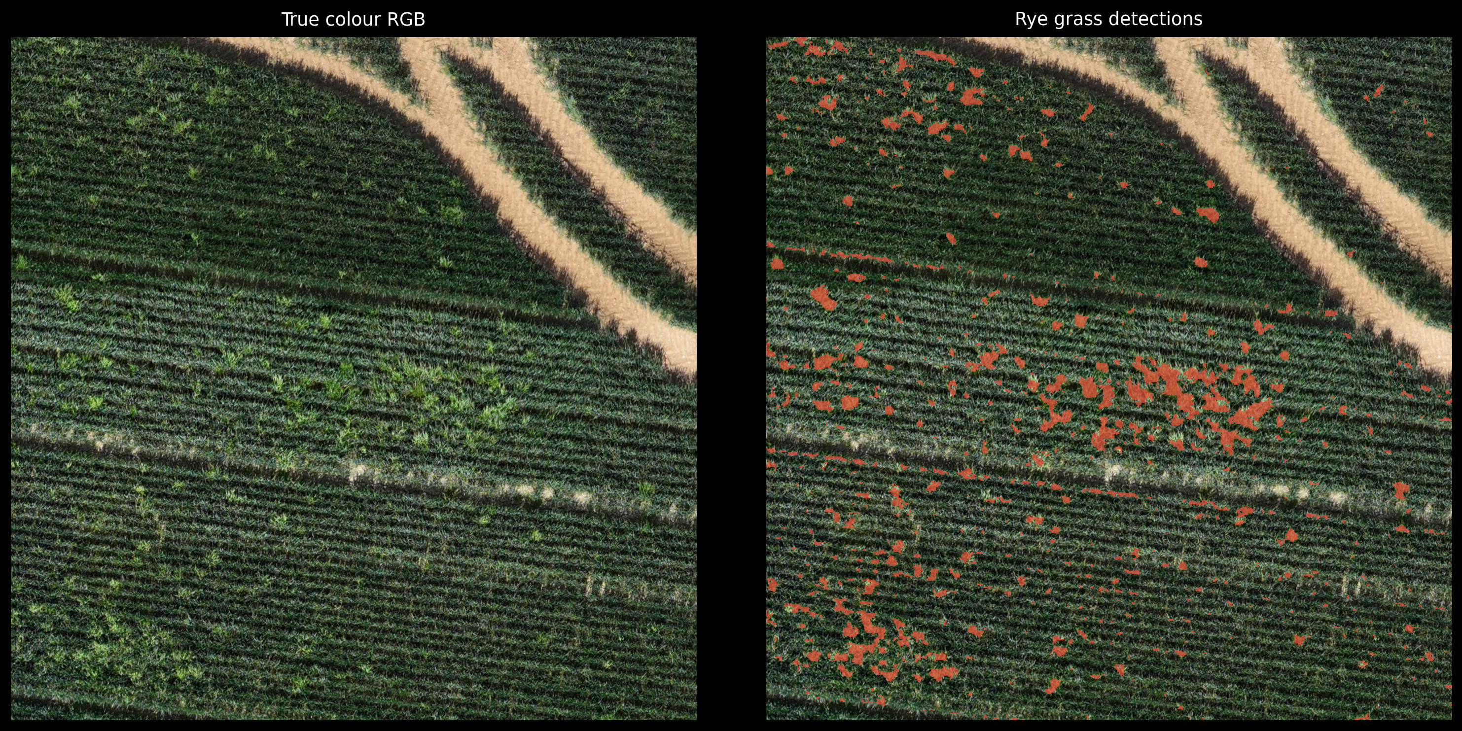
Individual ryegrass tillers resolved within the wheat canopy. RGB imagery (left) alongside classified detections (right).
From detection to prescription
The detection output feeds directly into a variable rate prescription, delivered ready for your sprayer:
- Prescription shapefile — spray / no-spray zones with GPS buffer, compatible with standard precision agriculture platforms
- ISOXML application map — direct upload to ISOBUS-compliant sprayer terminals
- Sprayer technology comparison — modelled spray area and product saving at individual nozzle control (25 cm and 50 cm) and boom section control, accounting for GPS update rate and controller reaction time
The saving is measurable before a sprayer enters the field: it is a property of the prescription itself. In a recent Hampshire winter wheat survey, the spot-spray prescription reduced the treated area by 61–67% versus blanket application with individual nozzle control (34% with 4 m section control). At typical contact herbicide costs of around £70/ha, that equates to roughly £40/ha in product — meaning the survey fee is typically recovered on a single pass. See the full Hampshire ryegrass case study.
SFI26: the PRF2 connection
SFI26 action PRF2 — camera or remote sensor guided herbicide spraying — pays £43/ha/year, and the action allows the sensor technology to be used beforehand to create a map for the sprayer, rather than requiring sprayer-mounted cameras. MPA's georeferenced, dated weed detection outputs are designed to serve as that remote sensing data source.
For a farm entering PRF2, the annual payment alone is several times MPA's survey fee — before counting the herbicide saving. Eligibility depends on your agreement and the final action requirements: confirm with your agronomist or adviser.
Working with agronomists and consultancies
MPA is a survey data provider, not an agronomy practice. Weed detection outputs identify where the problem is — interpretation, product choice, timing, and treatment decisions sit with you and your qualified agronomist. We work routinely alongside agronomists and farm consultancies, delivering detection data and prescriptions under their direction across their client estates. If you advise multiple farms, talk to us about a working arrangement.
What you receive
- Full PDF survey report — detection statistics, patch distribution, methodology
- Filtered detection raster (full-resolution GeoTIFF)
- VRA prescription shapefile (spray / no-spray zones)
- ISOXML application map for ISOBUS terminals
- Sprayer technology savings comparison
- Full-resolution RGB orthomosaic
Ready to map your weed pressure?
Get in touch to discuss a weed detection survey for your farm or client estate.
Enquire About Weed Detection